
We’re losing 44,000 square kilometers (17,000 square miles) of ice per year in winter (March-to-March).
Last year, we watched the lowest ever sea ice measurement unfold. It wasn’t happy viewing. Here’s the graph just after the low point – as of October 16, the extent was 3.20 million square kilometers (1.23 million square miles) below the long-term average.
")
(source: http://nsidc.org/)
If we now look at winter, when the ice is reforming you can see what looks like good recovery, but note that the solid black line is the average and the dotted line the previous record low… so it’s still bad.
")
“While the March 2008 maximum was 780,000 square kilometers (301,000 square miles) greater than the past record low, set in March 2006, it was 540,000 square kilometers (208,000 square miles) less than the 1979 to 2000 mean and occurred later in the year. Including 2008, the linear trend for March indicates that the Arctic is losing an average of 44,000 square kilometers (17,000 square miles) of ice per year in March. Although March 2008 extent is greater than in recent years, the setup looks right for another dramatic ice loss this summer.” [emphasis mine]
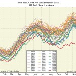
These images and graphs should be part of the weather forecast every day on every TV and Radio channel.